
NATRF2022, PATRF2022, CATRF2022, and MATRF2022
Four new terrestrial reference frames will replace the North American Datum of 1983 (NAD 83). They will serve as a foundational component of the modernized NSRS, providing precise definitions for geodetic latitude, longitude, and ellipsoidal height.
All of the frames are identical to the International Terrestrial Reference Frame of 2020 (ITRF2020) at epoch 2020.0 (January 1, 2020). As time elapses from 2020.0, each reference frame rotates with the stable part of their tectonic plate, thereby minimizing changes in coordinates due to plate motion.
Transformations from ITRF2020 to the reference frames for the North America (NATRF2022), Pacific (PATRF2022), Caribbean (CATRF2022), and Mariana (MATRF2022) tectonic plates are made using Euler Pole Parameters (EPPs). The Beta EPPs in this table were derived using velocities relative to ITRF2020.
| PLATE | Omega X (mas/yr) | Omega Y (mas/yr) | Omega Z (mas/yr) |
|---|---|---|---|
| NATRF2022 | 0.046 | -0.704 | -0.047 |
| CATRF2022 | -0.056 | -0.957 | 0.589 |
| PATRF2022 | -0.409 | 1.063 | -2.188 |
| MATRF2022 | -8.089 | 5.937 | 2.159 |

All values are in milliarcseconds/year. Rotation is positive counterclockwise following the right-hand rule.
The following equations can be used to transform Cartesian coordinates from a point i determined at epoch t using GNSS in the ITRF2020 frame to coordinates in one of the four plate-fixed reference frames:

where the adjustments to the coordinates of the point i in the global ITRF2020 frame g relative to a plate-fixed frame f (NATRF2022, PATRF2022, CATRF2022, or MATRF2022) are computed from
with K = π/(648 x 106), which converts milliarcseconds to radians, and Δt = t - 2020.0
Data Download
Download the EPP values for all four plates. A test dataset for software developers will be released publically on GitHub after completing internal review. To provide feedback on any of the content on this site, please email ngs.feedback@noaa.gov.
NATRF2022
NATRF2022 Euler pole parameters transform coordinates from the ITRF2020 frame of the NSRS to the North America plate frame. Coordinates of points located within the stable interior of this tectonic plate should evolve slowly with respect to the NATRF2022 frame. However, many points will exhibit residual motions associated with plate boundary zone deformation in the west, glacial isostatic adjustment, localized subsidence, or other causes.

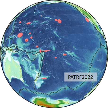
PATRF2022
PATRF2022 Euler pole parameters transform coordinates from the ITRF2020 frame of the NSRS to the Pacific plate frame. Coordinates of points located within the stable interior of this tectonic plate should evolve very slowly with respect to the PATRF2022 frame. Unlike the North American and Caribbean plates, the Pacific plate does not experience appreciable large-scale strain. Points very near plate boundaries or on volcanic islands, such as the big island of Hawaii, may exhibit relatively localized residual motions.
CATRF2022
CATRF2022 Euler parameters transform coordinates from the ITRF2020 frame of the NSRS to the Caribbean plate frame. Coordinates of points located within the stable interior of this Caribbean plate should evolve slowly with respect to the CATRF2022 frame. However, many points in the Caribbean region are located near active faults along the periphery of the plate, and others are located on volcanically active islands. Therefore, some stations are expected to exhibit residual motions associated with plate boundary zone or volcano deformation.

MATRF2022
MATRF2022 transforms coordinates from the ITRF2020 frame of the NSRS to the Mariana plate frame. Coordinates of points located within the stable interior of this tectonic plate should evolve slowly with respect to the MATRF2022 frame. However, many points in the volcanically active Mariana Islands region are located along the margin of the Mariana. Therefore, some points may exhibit residual motions associated with plate boundary zone or volcano deformation. The Mariana plate is a small, crescent shaped plate between the Pacific and Philippine plates. Guam and the Commonwealth of the Northern Mariana Islands (CNMI) are on this plate and home to many US citizens and interests. Given its small size, no good visual is available as for the other three plates.