Editing Project Data
To access the project data form, select ‘Edit>Project Data’ from the main menu.
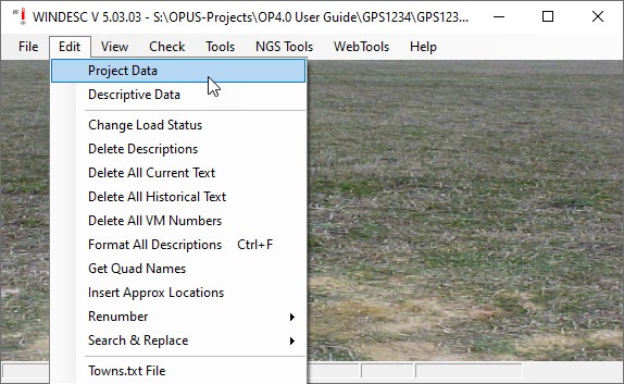
Accessing Project Data in WinDesc
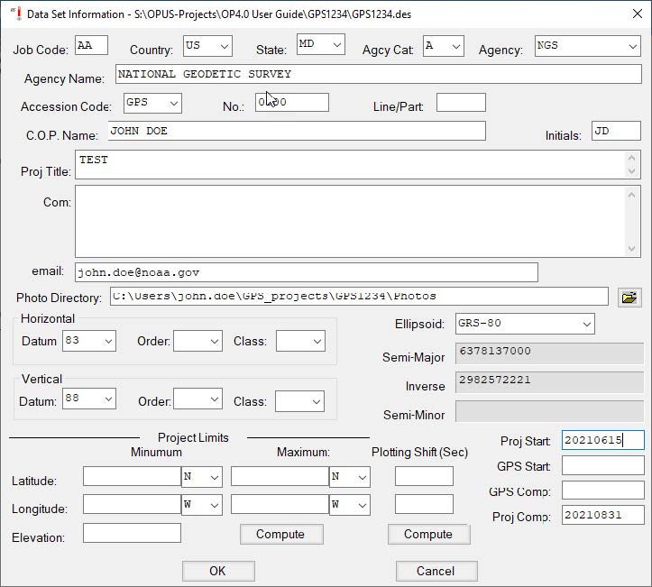
Sample WinDesc Project Data screen
Job Code: User-defined, but recommended to always use “AA.”
Country: Select appropriate country for project from the drop-down menu
State: Select appropriate state for project from the drop-down menu.
Agcy Cat Code: Drop-down menu; select the appropriate category for you/your agency. The category codes help organize and identify the “agency” assigned to the user for the purpose of submitting information and data to the National Geodetic Survey. Note that a private individual, or “none” as codes can be found under “M - Non-Specific Designators.”
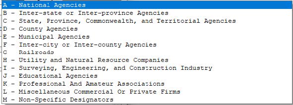
NGS Agency categories drop-down menu
Agcy symb: When the Agency Category Code is selected, the corresponding available Agency Codes are available in the drop-down menu. You can type the Agency Code or scroll to the correct code. Once the code field is entered, the Agency Name will fill in automatically.
If a user is not sure whether their agency has a code they can look it up in the Contrib.dat file (found in the PC’s WinDesc folder), or look it up online: (https://www.ngs.noaa.gov/cgi-bin/get_contrib.prl).
If a user cannot find the corresponding agency and would like to register the agency, the user can send an email request to ngs.annexc@noaa.gov.
Accession Code: For any GPS project, accession code is “GPS.”
[Accession] No.: Accession numbers are assigned by NGS after a survey project proposal has been reviewed and approved. Please submit your proposal on the Project Proposal website. If not using an accession number, this can be lest blank.
Line/Part: Typically blank for most GPS projects in OP
C.O.P. Name: Enter the Chief of Party name
Initials: Enter the Chief of Party initials
Proj. Title: Enter the name of the project. This should be the same name as the one assigned to the project.
Com.: Comments are optional.
Email: Sharing an email address will allow NGS to contact you if there are any issues or questions about your description files.
Photo Directory: Processing mark descriptions in WinDesc allows the user to correctly format, edit, label, and submit all the required photos for the project. Identifying the directory containing all of the photos simplifies the identification and processing of the photos.
Horizontal/Datum/Order/Class: The default horizontal datum is 83; leave as-is.
Vertical/Datum/Order/Class: The default vertical datum is [NAVD] 88; leave as-is for projects in the Continental USA (“CONUS”) and Alaska. For projects outside CONUS, please choose the appropriate datum in the drop-down list (e.g. International Great Lakes Datum, Puerto Rico Vertical Datum, “other,” etc.).
Ellipsoid: Leave blank or select GRS-80.
Project Limits: Leave blank
Proj Start and GPS Start: Enter the date (yyyymmdd) that the project and GPS observations started. GPS Comp and Proj Comp: Enter the date (yyyymmdd) on which the GPS observations were completed and the project was completed.
Click OK to save the project data.